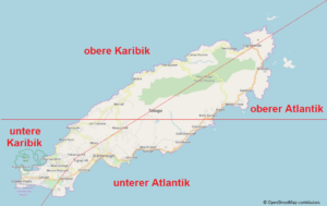
The Island of Tobago
Position: latitude 11°N, longitude 60°W . Trinidad & Tobago are the southernmost islands of the Lesser Antilles. Trinidad is located only 11 kilometers off the coast of Venezuela and from there separated by the Gulf of Paria. Tobago is located about 30 kilometers north-east of Trinidad. (learn more about beaches and bays)
Extent: 40.7 kilometres long; 11.9 km wide
Surface area: 300km2
Highest elevation: Pigeon Peak – 576 meters
Form of government: Democratic multi-party system
Population: approx. 61,000 (2011)
Ethnic groups: Trinidad & Tobago total – 40% African, 40% Indian, 18% mixed, 0.6% European, 0.4% Chinese, 0.6% others. On Tobago the proportion with African roots is 93%.
Religion: 35 % Anglicans, 11 % Methodists, 10 % Moravians, 10 % Adventists, 8 % Catholics and under 1 % Hindus
Largest and most important cities: Scarborough, Roxborough, Charlotteville
Structure: two regions – Western and Eastern Tobago
Industry: tourism (approx. 40,000 visitors per year) and fishing
Currency: Trinidad & Tobago Dollar (TT$) (learn more)
Current: 110 Volt / 60 Hz (learn more)
Language: English
Climate: Tropical (learn more)
Shopping: Most shops on Tobago are closed on Sundays. Supermarkets are open from 8:00 to 20:00. Usually shops are open during the week from 8:00 to 16:30 and on Saturdays from 8:00 to 12:00. In tourist areas, opening on Sunday is not uncommon. (learn more)
Sun times: sunrise – 06:00 h; sunset – 18:30 h
Time: 4 hours behind Greenwich Mean Time (GMT) or 6 hours behind Central European Summer Time (CEST)


